2019
June 18th-20th, Yreka, California

SCHEDULE OF EVENTS
Tuesday, June 18, 20194:00 pm to 7:00 pm Registration
5:00 pm to 6:30 pm Reception (no-host)
6:30 pm to 9:00 pm Dinner
Wednesday, June 19, 2019
7:00 am to 8:00 am Breakfast
8:00 am to 8:10 am Welcome and Introductions
8:10 am to 11:40 am Technical Presentations / Demonstrations
11:40 am to 12:35 pm Lunch
12:35 pm to 5:00 pm Technical Presentations / Demonstrations
5:00 pm to 5:15 pm Comments, Discussion, Evaluations
6:15 pm Evening Dinner and Networking Session
Thursday, June 20, 2019
7:00 am to 7:45 am Breakfast
7:45 am to 7:50 am Welcome and Introductions
7:50 am to 11:40 am Technical Presentations / Demonstrations
11:40 am to 11:55 am Speaker and Attendee Recognition
11:55 am to 12:00 pm Concluding Remarks, Evaluations
12:00 pm to 1:00 pm Lunch
Organic vs. Purchased Data for Travel Time Predictions
Andres Chavez
Caltrans District 3

|
Caltrans District 3 has used several different data sources for calculating travel times. Data has been collected from their own sources such as single and dual loops, radar, Bluetooth, and WiFi. They’ve also used two external sources – Waze and HERE. Transportation electrical engineer Andres Chavez reviewed how District 3’s travel time data sources have moved from loops, to Bluetooth, to Waze and HERE data. He presented pros and cons for the various sources and technical details on how the data was acquired and utilized. He examined the South Lake Tahoe Case Study and concluded with a frank discussion on next steps. |

UDOT’s Region Four Rural Intersection Conflict Warning Systems (RICWS) Design and Implementation
Troy C. Torgersen, P.E., Robert Dowell, P.E., Tyler Turner, P.E.
Utah Department of Transportation, Civil Science

|
In an effort to reduce the number of serious crashes at rural intersections, Utah DOT’s Region Four, which is mostly rural, began researching the state of the practice for rural intersection safety. The results ultimately guided the design and deployment of three Rural Intersection Conflict Warning Systems (RICWS). In this presentation, UDOT’s Troy Torgersen and Robert Dowell, and Tyler Turner from Civil Science, reviewed the locations of the systems and why they were chosen, then discussed warrants and guidelines including scenarios, sign type and placement, messages, detection type, power supplies, and system monitoring, communications, and data management. They provided details on site planning, equipment, system installation, and operations. They concluded by sharing lessons learned through the development and deployment of the various systems. |

Design, Development, and Field-Testing of the Caltrans Responder System
Stephen Donecker, Melissa Clark
AHMCT UC Davis; Caltrans Division of Research, Innovation, and System Information


|
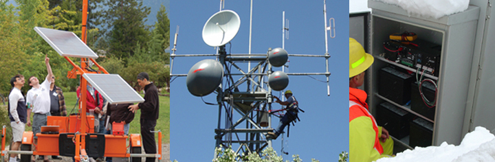
Caltrans maintenance staff respond to incidents on state roadways and collect information, determine appropriate responses, and access and manage resources on the scene. The Caltrans Responder System was designed and developed as a more efficient and effective means to collect and share at-scene incident information with TMCs and emergency responders. The comprehensive tool allows incident responders to communicate photos, drawings, road/weather information, and maps, during an active incident via cellular, satellite, or other communications. UC Davis researcher Stephen Donecker, and Caltrans DRISI project manager Melissa Clark, started with some history and rationale for the system, and then discussed system architecture, hardware, and software. They discussed implementation, design considerations and solutions, and what did and didn’t work. Stephen demonstrated the portable system during breaks and networking sessions. |


Foresight is 2020: NDOT Building an ITS Network for the Next Decade and Beyond
Jim Whalen, Gary Molnar, Mark Aragon
Nevada Department of Transportation

|
Nevada DOT is looking towards the future and taking steps to ensure their ITS Network can accommodate new and emerging technologies; for example, advanced applications that gather and exchange information in real-time, traveler information, monitoring and security, or connected and autonomous vehicles. Jim, Gary, and Mark shared what they did to build their ITS Network for the future and lessons learned. The team discussed project planning, requirements definition, lifecycle needs and cost-benefits, logistics around a wholesale upgrade, resource requirements and allocation, equipment, and operational challenges and solutions. They shared details on the progress made in the last year and the tools they now have to successfully meet the demands of the future. |

Fiber Optic Systems in Rural Areas: Building and Leveraging Fiber Systems
Lynne G. Yocom
Utah Department of Transportation

|
Utah DOT’s Fiber Optics Manager Lynne Yocom shared UDOT’s strategies for installing and accessing fiber optic systems in rural areas. The system they have put together through installation and trades with private telecommunication companies now allows UDOT to monitor and manage small pockets of traffic signals in rural towns, gather robust weather data to support plowing and maintenance operations, and install traffic cameras in areas with higher numbers of crashes and/or weather incidents. Lynne provided some background and history behind the work being done, discussed basic information on fiber optics systems, including typical installation and costs, and showed the growth and extent of UDOT’s fiber network. She then focused on how the trade agreements are structured and reviewed the details for several examples from Utah. |

ODOT Connected Vehicle Applications
Julie Kentosh, P.E., PTOE, Doug Spencer, P.E.
Oregon Department of Transportation


|
Traffic Operations Engineer Julie Kentosh and ODOT’s ITS Standards Engineer Doug Spencer teamed up to discuss ODOT’s work with connected vehicle applications and the pilot project deployed in Salem. They started with a brief overview of connected vehicle concepts and industry interest, the AASHTO SPaT Challenge, and MAP data. They discussed how ODOT is testing sharing intersection data over the internet from a central connected vehicle (CV) server or through DSRC radios at the roadside via a local CV system. The CV configuration utility uses an integrative approach – Julie and Doug discussed how the system has one setup that is congruent with CV applications in addition to adaptive signal control and signal performance metrics. They showed the In-Car Reference App and reviewed how the MaxView Connected Vehicle application is being used. They concluded with an overview of the local connected vehicle pilot project and the related research questions, along with some of the other projects that are part of Oregon’s Smart Mobility Network funding. |


Miovision Equipment for SPAT Challenge – Intended and Actual Outcomes
Ken Burt
Washington State Department of Transportation

|
Ken Burt, a signal operations engineer in Washington State DOT’s Olympic Region, reviewed the region’s experience with Miovision equipment and the AASHTO SPaT Challenge. Ken provided some history and background for the project, the vendor, equipment, and Olympic Region signal system, and how the test route was chosen. He briefly demonstrated some of the system’s features and described how the system was used during a major incident. While Miovision chose not to follow through on the equipment and the SPaT Challenge, there were still several beneficial outcomes from the project. Ken discussed the various alerts that are now available to them, as well as the automated traffic signal performance measures (ATSPMs), and remote connections to signals over the Internet to cellular controlled controllers. He finished with a quick review of related projects in the other WSDOT regions. |

The Maintenance Decision Support System (MDSS)
Michael J. Adams
Wisconsin Department of Transportation

|
Upon suggestion from a regular Forum attendee, Michael Adams, the Road Weather Program Manager from the Wisconsin DOT presented the Maintenance Decision Support System (MDSS). Michael started with an overview of the MDSS system, what it is, and what it is used for, along with some history of how the system was first developed and has since evolved. He discussed how the system’s output is used by management, field supervisors, and snowplow drivers to enhance winter operations. Michael reviewed the components of the system including weather and pavement forecasts, treatment recommendations, and management tools that allow route-by-route post-storm analysis and the ability to save storm data for future training. A brief demonstration of the system was included. |

TOP